Hurricane season is underway, and Hurricane Hillary is already making her presence known. Gale, Tomorrow.io’s first-of-its-kind weather and climate-generative AI, has analyzed Hillary’s potential impacts for key business regions in her path.
Here’s what to expect and how to prepare your operations in key locations directly in the storm’s path:
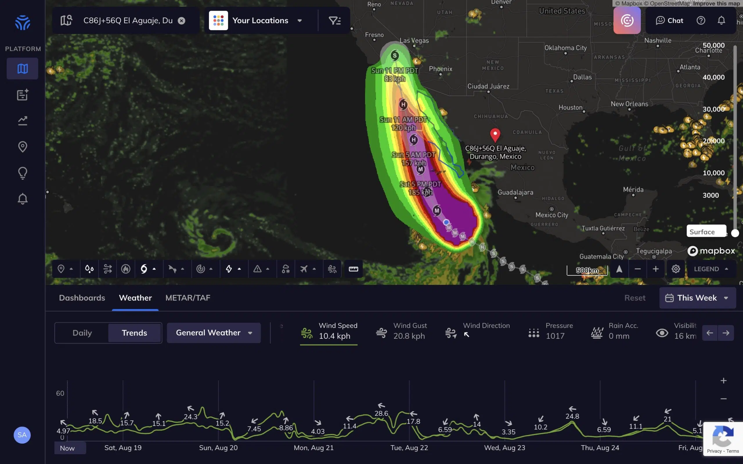
Baja California
- From August 18-19, Baja California will see dry weather with wind speeds increasing from 8 to 20 kph.
- Starting August 19, rainfall will significantly increase, peaking at 6 mm/hr on August 20.
- Wind speeds will also peak at 64 kph on August 20 before decreasing.
Los Angeles
- Los Angeles can expect dry weather until August 20.
- From August 20-24, heavy rainfall is expected, with peak intensity of 14 mm/hr on August 21.
- Wind speeds will reach up to 21 kph during this time.
San Francisco
- San Francisco will see dry weather until August 19, followed by light rainfall from August 19-24 peaking at 2 mm/hr on August 20.
- Wind speeds will reach 10 kph.
Preparing for High-Impact Weather: Gale’s Suggestions for Hurricane Hillary
Regardless of your industry, businesses should prepare for incoming high winds and rainfall by:
- Securing any outdoor equipment or materials that could be affected by high winds or heavy rainfall.
- Reviewing your business continuity plan for severe weather events, ensuring that all team members are aware of their roles and responsibilities.
- Considering flexible work arrangements for your team during this period, such as remote work options, to minimize travel during heavy rainfall and high winds.
- Ensuring that your premises are well-maintained and prepared for heavy rainfall, checking for any potential leaks or drainage issues.
- Staying updated with the latest weather forecasts and warnings to make timely decisions.
Enhance Preparedness with Tomorrow.io’s Tropical Cyclone Data
Tomorrow.io’s Tropical Cyclone Data Layer enables businesses to visualize official cyclone forecasts, monitor tracks and cones of uncertainty, and access predictive insights for winds, rain, and flooding. Our recently enhanced product provides advanced wind analytics for superior storm preparedness.
With this enhanced data, organizations can review four separate cyclone-specific data layers and three additional advanced graphical layers including:
- Forecast Track
- Cone of Uncertainty
- Watched and Warning
- Observed Track
- Wind Probability (34 knots and 64 knots): The tropical cyclone surface wind speed probabilities layers provide probabilities, in percent, of sustained wind speeds equal to or exceeding 34-, and 64-knot wind speed thresholds.
- 5-day Wind Swath: The wind swath conveys the expected areal coverage of 34 knot, 50 knot, and 64 knot sustained winds (based on the NHC forecast) that are directly produced by the tropical cyclone as it moves along the forecast track.
Don’t let the next hurricane disrupt your operations. Leverage Tomorrow.io’s technology to monitor cyclone threats, gain situational awareness, and proactively prepare your business.